
In the evolving landscape of modern surveying, precision and efficiency are non-negotiable. At Scantech Surveys, we deliver world-class 3D LiDAR surveys, cutting-edge drone mapping and surveying in Perth, and detailed internal building surveys that set the benchmark for accuracy, safety, and technological innovation. From major infrastructure developments to confined interior assessments, our expert team provides reliable spatial data that transforms the way you plan, design, and execute your projects.
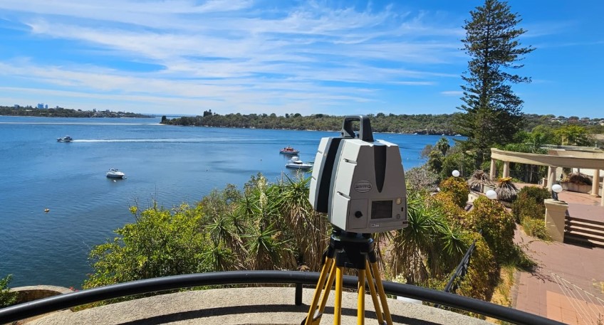
Next-Generation 3D LiDAR Surveys
3D LiDAR (Light Detection and Ranging) is revolutionising spatial data collection by using laser pulses to measure distances and generate precise 3D point clouds of real-world environments. This technology captures vast areas or complex objects with sub-centimetre accuracy, even in low-light or vegetation-dense conditions.
Our 3D LiDAR Survey Capabilities:
- Terrestrial LiDAR Surveys: Ideal for ground-level scanning of structures, roadways, and construction sites.
- Mobile LiDAR: Mounted on vehicles for rapid data capture of roads, railways, and corridors.
- Aerial LiDAR: Delivered via drone for topographic surveys, forestry, and infrastructure mapping.
Benefits of 3D LiDAR Surveys:
- High-speed data acquisition
- Accurate and dense point cloud generation
- Effective in challenging terrains and environments
- Perfect for large-scale or linear infrastructure
Our team leverages LiDAR to support planning, monitoring, and analysis across industries such as civil engineering, energy, urban planning, and more.
Advanced Drone Mapping and Surveying Services in Perth
When it comes to drone mapping and surveying in Perth, Scantech Surveys leads with high-resolution aerial solutions that provide unmatched coverage and accessibility. Our licensed drone operators and surveyors utilise state-of-the-art UAV platforms equipped with both photogrammetry and LiDAR payloads.
Drone Surveying Applications:
- Topographic Mapping: Rapid acquisition of terrain data for site planning and design.
- Stockpile and Volume Calculations: Monitor materials accurately for resource management.
- Construction Progress Monitoring: Capture consistent, up-to-date aerial views of your site.
- Environmental and Agricultural Surveys: Assess vegetation, erosion, and water flow.
- Asset Inspection: Safe and efficient inspection of hard-to-reach structures like rooftops, towers, and bridges.
Why Choose Drone Mapping in Perth?
- Rapid deployment and data turnaround
- Cost-effective for large or remote sites
- Highly detailed orthoimagery and digital surface models
- Improved safety with reduced need for manual access
Our drone surveys are georeferenced and integrated seamlessly with GIS, CAD, and BIM environments, ensuring accuracy and usability across your workflow.
Detailed Internal Building Surveys in Perth
Understanding the internal structure of a building is crucial for renovation, compliance, retrofitting, and asset management. Our internal building survey services in Perth provide comprehensive documentation of indoor spaces using a combination of laser scanning, total stations, and 3D modelling software.
Internal Survey Capabilities Include:
- Floor plans, elevations, and cross-sections
- As-built 3D models for interior architecture
- MEP (Mechanical, Electrical, Plumbing) layout documentation
- Scan-to-BIM for accurate digital twins
- Ceiling void and plant room scanning
Whether you’re an architect, facility manager, or developer, our surveys ensure that your interior data is accurate, detailed, and ready for immediate use.
Applications of Internal Building Surveys:
- Building Refurbishments and Renovations
- Space Planning and Fit-outs
- Compliance with Fire Safety and Accessibility Regulations
- Heritage Building Conservation
- Structural Assessments
We specialise in accessing confined, complex, or operational spaces without disrupting building occupants or operations, ensuring minimal impact and maximum detail.
Why Scantech Surveys is the Industry Leader in Perth
1. Cutting-Edge Technology
We invest in the most advanced surveying equipment on the market, including Leica LiDAR systems, DJI and senseFly drones, FARO scanners, and high-precision GNSS receivers. This enables us to offer superior accuracy, speed, and reliability across all services.
2. Highly Skilled Professionals
Our surveyors are not only certified and experienced but also passionate about precision and innovation. Every project is executed with a commitment to quality and safety.
3. Versatile Deliverables
From raw point clouds to fully rendered 3D BIM models, we tailor deliverables to suit your software and project needs. Formats include .e57, .rcs, .las, Revit, AutoCAD, and more.
4. Fast Turnaround Times
We understand that time is money. Our streamlined workflow ensures rapid data processing and delivery without compromising on accuracy or detail.
5. End-to-End Support
From pre-survey planning to post-processing consultations, we offer full-service support for projects of all sizes. Our team works closely with clients to ensure seamless integration of spatial data into their planning, design, and construction processes.
Industries We Serve in Perth
- Construction and Civil Engineering
- Mining and Resources
- Utilities and Infrastructure
- Oil & Gas
- Architecture and Urban Design
- Real Estate and Property Management
- Government and Transport
Case Study: Integrated Surveying for Commercial Redevelopment
A major developer in Perth required both external site modelling and detailed internal building data for a large commercial redevelopment. Scantech Surveys provided:
- Aerial drone mapping of the site and surroundings
- 3D LiDAR scanning of the existing structure
- Internal building survey capturing every floor, utility space, and service cavity
- BIM-ready models delivered within a week
The result was a complete digital twin that streamlined planning approvals, design coordination, and construction tendering.
Get in Touch with Scantech Surveys Today
If you’re searching for reliable, high-tech surveying solutions in Perth, trust Scantech Surveys for expert 3D LiDAR surveys, precise drone mapping, and thorough internal building surveys. We bring together accuracy, innovation, and deep local experience to support your project’s success from start to finish.